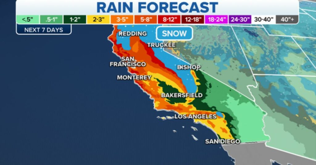
SAN FRANCISCO – What has been a wet end to 2022 is going to get even soggier as another atmospheric river aims at California later this week into the weekend, bringing with it a renewed threat of flooding rains and heavy mountain snows. This will get the total amount of precipitation that has fallen in California in 2022 to a total of 118.8 inches.
On Thursday, the first swath of precipitation will move down the entire length of the Pacific Coast, from Washington to Northern and Central California, including the Bay Area. It will extend all the way down to Mexico. The sum of all the rain that falls is expected to be between half an inch and an inch.
Flood Watches have been issued for a large portion of the region, including the Bay Area, as a result of a new wave of heavier rain that is expected to arrive in California on Friday in conjunction with the latest in a string of atmospheric rivers that are moving toward the Golden State.
Rainfall that is moderate to heavy is expected to hit Northern California on Friday. Then the atmospheric river will turn its attention to Central California and the Bay Area late Friday night and early Saturday morning, where it will continue to wreak havoc. The Southern California regions of Los Angeles and San Diego are in for a wet start to 2023 as steady rains move south into Southern California on Sunday while Northern California gets a break from the damp weather.
The coastal lowlands of southwestern Oregon into Northern and Central California are expected to receive roughly 2-3 inches of rain as a result of the storm from Friday through Sunday. In contrast, the hills are expected to receive higher amounts.
Rainfall between three and five inches is expected to fall in the inland regions by Saturday night. In contrast, only about an inch of precipitation is anticipated in Southern California on Sunday. Even the dry regions of Arizona, such as Phoenix and Tucson, will receive between half an inch and an inch’s worth of precipitation as a result of the storm.
The storm is expected to dump two to three feet of snow on the Sierra Nevada’s highest elevations; however, because snow levels are expected to rise as high as 7,000 to 8,500 feet, the majority of the mountains will be hit with several inches of rain instead, which will put additional strain on the region’s rivers. Another danger to watch out for is flash floods, particularly in areas that wildfires have recently ravaged.
Once it has finished wreaking havoc on the West Coast, this storm will exert its impact on the weather pattern over the Rockies around the end of the week. In most mountains, there is a good chance of receiving anywhere between 2-10 centimeters of snow, with depths of up to 3 meters probable. Although it should continue to be a rainy event for Salt Lake City, the Wasatch Range should brace itself for significant snowfall.
It is expected to snow between 3 and 5 inches in Denver over the next several days, which could create difficult travel conditions. According to FOX 31 Denver, the city’s Thursday morning commute was disrupted by a number of accidents involving spin-outs.
Avalanches will be a risk across the majority of mountain ranges moving into the weekend, in addition to the snow that is expected. Even though Sunday night will mark the beginning of a new year, the wet weather pattern that has been prevalent along the West will not change.
The following week will bring additional storms to California, which are expected to occur roughly every 48 hours. The long-range forecast maps suggest that much of California could receive between 4 and 8 inches of total rainfall from the various storms expected to pass over the state through the end of the following week.
Please share your opinions on this story in the space provided below. And remember to check back here, Journalistpr.com. for updates on the situation.

