
A Strong Winter Storm Is Dumping Snow In Sierra Nevada, And Flood Watches Have Been Issued In California.
Sunday, a strong winter storm hit the West, dumping more than 7 inches of rain in some parts of Southern California and threatening to dump feet of snow in some places from the mountains of the Golden State to the Midwest.
The storm will keep moving across the West, and the National Weather Service says it could turn into a blizzard in the next few days. From Monday to Wednesday, the system was expected to move across a large part of the country, from Colorado to Minnesota. It was expected to bring snow, high winds, and freezing rain.
The weather service said that heavy snow will have big effects in many parts of the country. “It might not be possible to go anywhere.” The highway patrol said that heavy snow in the Lake Tahoe area closed a section of California Highway 89. The weather service said that parts of the Sierra Nevada could get 5 feet of snow and whiteout conditions on Sunday and Monday. There were also times when parts of I-80 and other roads were closed.
As the storm moves east, parts of I-90 and I-94, which are the main highways in the Upper Midwest, may have to close because of the snow. The weather service said that a “bowling ball” in the atmosphere could bring snow and a small chance of storms to southwest California on Sunday. The bowling ball is expected to move across the northwest and southeast parts of the region late Sunday night or early Monday morning.
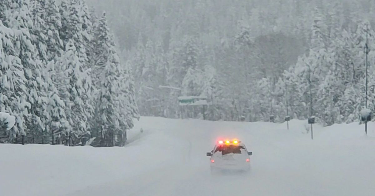
A Lot Of Snow In The Sierra Nevada And Lake Tahoe
The weather service said there was a lot of snow in the mountains of northeast California, the area around Lake Tahoe, western Nevada, and the Eastern Sierra Nevada.
The weather service says that up to 48 inches of snow have fallen in the Greater Lake Tahoe area since Friday. The weather service also warned of dangerous travel conditions in the mountains that will last until early Monday morning. Above 4,500 feet in the Sierra Nevada, it could snow another 1 to 2 feet.
Sunday night, an outage map from Liberty Utilities showed that almost 22,000 people around Lake Tahoe did not have power. The map showed that the power should be back on by Monday at 12 p.m. PST. There is still a winter storm warning for the area, and overnight temperatures are expected to be between freezing and below freezing.
Southern California Gets A Lot Of Rain; The South Could Get Flooding And Tornadoes
The weather service said that parts of Ventura and San Luis Obispo counties in southern California were getting more than 7 inches of rain. Some parts of Los Angeles County got more than 4 inches of rain, and some parts of southwestern California got up to an inch of rain an hour. In some places, the total amount of rain was 3 inches.
Flash flooding and debris flows were a worry, especially in and around areas of the drought-stricken region that had recently been burned by wildfires. The first band of heavy rain left Los Angeles County just before 9 a.m. PST on Sunday, but the weather service says there will be showers all day and all night. The Bay Area is also likely to see a few showers and a small chance of hail through Sunday.
The weather service said that there were “very heavy downpours” and strong wind gusts of up to 80 mph in San Luis Obispo County on Saturday night. The Grover Beach Police Department said that several power lines fell Saturday night in the county, cutting off all phone and 911 lines.
PG&E says that almost 30,000 people were without power on Saturday night. By Sunday afternoon, most of the power had been turned back on in the county, but PG&E’s outage center map showed that more than 7,500 people still didn’t have power.
The National Weather Service said that Arkansas, Louisiana, Mississippi, and Texas could have bad weather on Tuesday and Wednesday. The weather service said that severe thunderstorms could bring tornadoes, strong winds, and hail.
North California And Northwest Nevada Are Expected To Have Freezing Temperatures
As the winter storm moves out of northern California and northwest Nevada, the weather service predicts that overnight lows will be close to freezing for the next week.
The weather service put out a freeze watch from late Monday night until early Tuesday morning. Temperatures below freezing could also happen late Tuesday night or early Wednesday morning.
From Colorado To Minnesota, A “Major” Snowstorm Is Expected
AccuWeather meteorologist Thomas Geiger said that a strong low-pressure system that is expected to form over Colorado and Kansas on Monday will pull moist air from the Gulf of Mexico north and mix it with very cold air from Canada’s polar regions. “By the middle of the week, there will be a big snowstorm from Colorado to Minnesota,” he said.
The worst of the storm could hit late Tuesday or early Wednesday. In some places, it could snow as much as several inches per hour. Geiger said that the wind could gust up to 60 mph. The Boulder officer of the weather service tweeted, “Blizzard conditions are possible for parts of northeast Colorado late Monday night through Tuesday night.” “There could be big problems with travel, whiteouts, road closures, and tough conditions for livestock.”
As the storm gets stronger, the snow will keep moving east. There could be snow and ice in some parts of Minnesota. Geiger said that even a tenth of an inch of ice could be dangerous.
Some Places Will Get A Thick Coat Of Ice
Geiger said, “In much of central and southern Minnesota, a thick layer of ice may be worse than the snow.” He said that some places in North and South Dakota that only get snow could get 2 feet of it.
Meteorologist Lauren Hyde from AccuWeather said that the storm could last all week. Still not clear is how it will affect the Northeast by the end of the week. But forecasters said that heavy snow and ice could be coming.
I hope you like our article. If so, please share your wise thoughts in our comments section. Add Journalistpr.com. to your bookmarks as well for more of these updates.
Leave a Reply