


As a Tropical Storm grows stronger, thousands of Floridians are being told to leave their homes. Nicole is expected to become a hurricane before it hits Florida’s east coast early Thursday morning. The National Hurricane Center says that hurricane warnings are now in effect from the Volusia-Flagler county line south to Boca Raton.
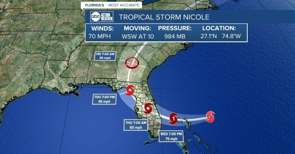
As of a report from the National Hurricane Center at 10 p.m. Tuesday, Nicole was 150 miles east-northeast of the northern Bahamas and 325 miles east of West Palm Beach. It had sustained winds of 70 mph and was moving west-southwest at 10 mph. Forecasters think that by Wednesday morning, the storm will move west-southwest, and then on Thursday, it will move northwest.
“Over the next day or so, Nicole is expected to get stronger, and forecasters say it will become a hurricane on Wednesday when it gets close to the northwestern Bahamas. It will still be a hurricane when it gets close to the east coast of Florida,” they said.
Volusia County issued mandatory evacuation orders Wednesday at 10 a.m., which must be followed by 4 p.m. The order applies to everyone who lives east of the Intracoastal Waterway, everyone who lives in a mobile home east of Interstate 95, everyone who lives in a low-lying or flood-prone area, and everyone who stays at a campground or RV park.
“This is important because Hurricane Ian did a lot of damage to many of our coastal properties, and this storm’s waves and storm surge make some structures more likely to be damaged or fall,” said Kevin Captain, the community information director for Volusia County.
Flagler County said on Tuesday that everyone living on its barrier islands from Flagler Beach to Marineland, as well as those in mobile homes, RVs, and low-lying areas, must leave by Wednesday. Brevard County, on the other hand, told people who live on barrier islands, in mobile homes or manufactured homes, in low-lying areas that are prone to flooding, or who need electricity for medical reasons to leave.
Farther south, Palm Beach County told residents on Tuesday to leave coastal neighbourhoods and other vulnerable places in case the storm hits. At a 2 p.m. news conference, County Mayor Robert Weinroth said that the county had told people in zones A and B to leave.
These zones include barrier islands, low-lying areas, and mobile home communities. Palm Beach County Administrator Verdenia Baker said that the evacuations start at 7 a.m. Wednesday and affect about 52,000 people who live in mobile homes in the county and about 67,000 people who live along the coast.
“We saw what happened in Lee County,” Weinroth said, referring to how people on the coast were drowned by the storm surge from Hurricane Ian. “There were people who stayed put because they thought there wasn’t an emergency, and many of them later regretted their decision.”
— National Hurricane Center (@NHC_Atlantic) November 8, 2022
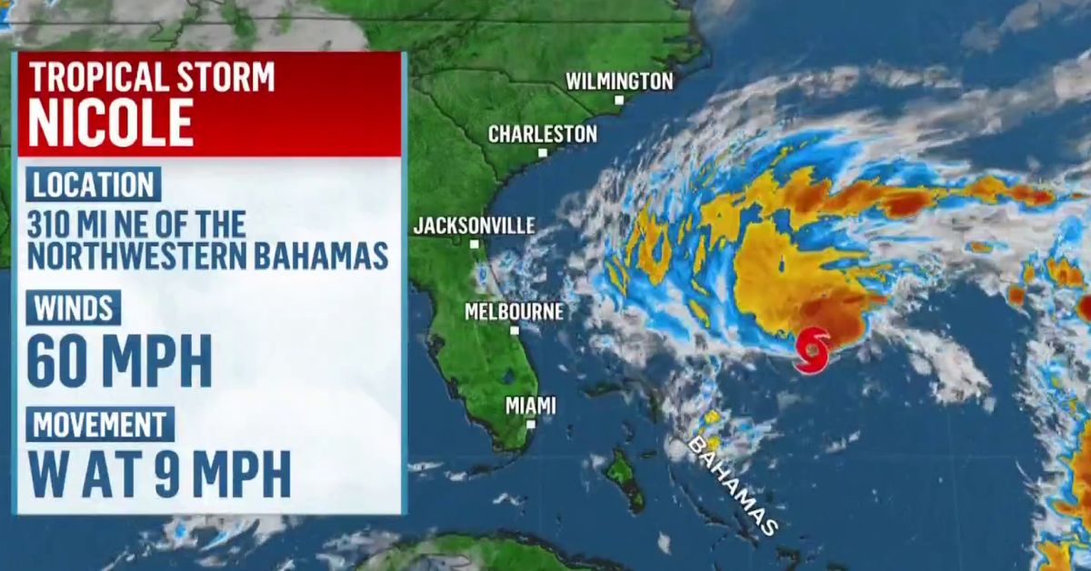
The system changed from Subtropical Storm Nicole to just a storm Tuesday morning as it moved over warmer water. This means that its centre should become clearer. It is getting stronger as it gets closer to the Bahamas and the Florida coast. On Tuesday morning, it had steady winds of 45 mph, and it is still getting stronger as it moves toward the Bahamas.
The NHC’s cone of uncertainty is still quite big, and the storm could move anywhere from Boca Raton in the south to Cape Canaveral in the north.
And because the storm is so big, the whole state could be affected, since winds that are strong enough to be called a tropical storm reach out 380 miles. As a result, the NHC warns of dangers that can be found hundreds of miles away from its centre.
The NHC said, “Don’t worry about Nicole’s exact path because it’s expected to be a big storm with dangers far to the north of the centre, outside of the forecast cone.” “These dangers are likely to affect a large part of the Florida peninsula and parts of the southeast U.S.”
A hurricane watch has been issued from the Volusia-Flagler county line north to Ponte Vedra Beach. This is in addition to the hurricane warning that goes from the southern part of Palm Beach County up through the Treasure and Space coasts. A tropical storm warning is still in effect from Hallandale Beach north to Boca Raton and the Volusia-Flagler county line north to Altamaha Sound, Georgia. Lake Okeechobee is also under a hurricane watch.
Earlier on Tuesday, the NHC put a tropical storm watch in place from north of Bonita Beach to the Ochlockonee River on Florida’s west coast. The National Weather Service in Melbourne has issued a hurricane warning for all of Brevard County. There are also inland tropical storm warnings for Lake, Marion, Orange, Osceola, Polk, Seminole, Sumter, and Volusia counties.
4 pm EST: #Nicole beginning to strengthen and expected to become a hurricane on Wednesday. See Key Messages below and visit https://t.co/tW4KeGe9uJ for details. pic.twitter.com/nGevzgOMtI
— National Hurricane Center (@NHC_Atlantic) November 8, 2022
But the system will move over the northwestern Bahamas before it gets to Florida. Abacos, Berry Islands, Bimini, and Grand Bahama Island are under a hurricane warning, while Andros Island, New Providence, and Eleuthera are under a tropical storm warning.
“There will be hurricane conditions in the northwestern Bahamas in the hurricane warning area on Wednesday, and all of the northwestern Bahamas will have tropical storm conditions by tonight,” forecasters said. “By Wednesday night, hurricane conditions are possible along the east coast of Florida in the hurricane watch area, and tropical storm conditions are expected tonight or early Wednesday. In the watch area along the west coast of Florida, a tropical storm could happen by Wednesday night.

On Tuesday, schools and government offices in Abaco, Bimini, the Berry Islands, and Grand Bahama were closed, and more than two dozen shelters were opened across the islands. As the storm gets closer, airports and seaports will close and won’t open again until Thursday. People in shantytowns were told to find a safe place to stay.
Tropical Storm #Nicole presents a commanding profile in #GOESEast satellite imagery today. So it’s no surprise hurricane conditions are expected for the northwest Bahamas and east coast of of Florida.
NHC updates: https://t.co/IKuTzUSsmY
Image updates: https://t.co/JOI3jlondp pic.twitter.com/21zKsKjS8S— UW-Madison CIMSS (@UWCIMSS) November 8, 2022
The communities in Abaco are still trying to get back on their feet after Dorian, so they are likely to get a direct hit from Nicole. The head of the emergency management authority, Capt. Stephen Russell, said, “We don’t have time to beg and plead with people to move.”
Even though there is a risk of damaging winds, the system is likely to bring more rain to Central Florida, which is still recovering from the flooding caused by Hurricane Ian in September. The National Hurricane Center (NHC) said that Nicole will bring 3 to 5 inches of rain, with some areas getting up to 8 inches. The National Weather Service (NWS) office in Melbourne said that the eastern parts of Osceola and Brevard Counties and the Saint Johns River basin could get up to 6 inches of rain.
The NWS said that flooding is becoming more likely in areas with poor drainage and in cities where the water table stays high. “The combination of heavy rain and strong northeast winds could also cause more flooding and standing water in the Saint Johns River basin, where river flood warnings are still in effect. Later today, a flood watch is likely to be put out for all of east central Florida.
The NWS said that 8- to 10-foot waves will start hitting the coasts of Brevard and Volusia today and get bigger as the system gets closer.
“There will still be a lot of dangerous rip currents. The strong winds and high waves, along with the ongoing high tides, will cause a big storm surge and a lot of beach erosion around the next few high tides from Tuesday to Thursday, according to the NWS. “Volusia County’s coastal areas, which were badly damaged by Hurricane Ian, are still at risk for more beach erosion and flooding from coastal flooding.”
The NHC’s storm surge warning said that water levels could rise 3 to 5 feet from North Palm Beach to Georgia and 2 to 4 feet from the mouth of the St. Johns River to Georgetown, Florida, in Putnam County, south of the river.
Comment below if you liked this story. And keep checking back here at Journalistpr.com for updates on the news. You Can Also Go For Meet The People Who Will Make History In The Midterm Elections Of 2022 And Five States Have Measures About Abortion On Their Midterm Elections Ballots